Project File
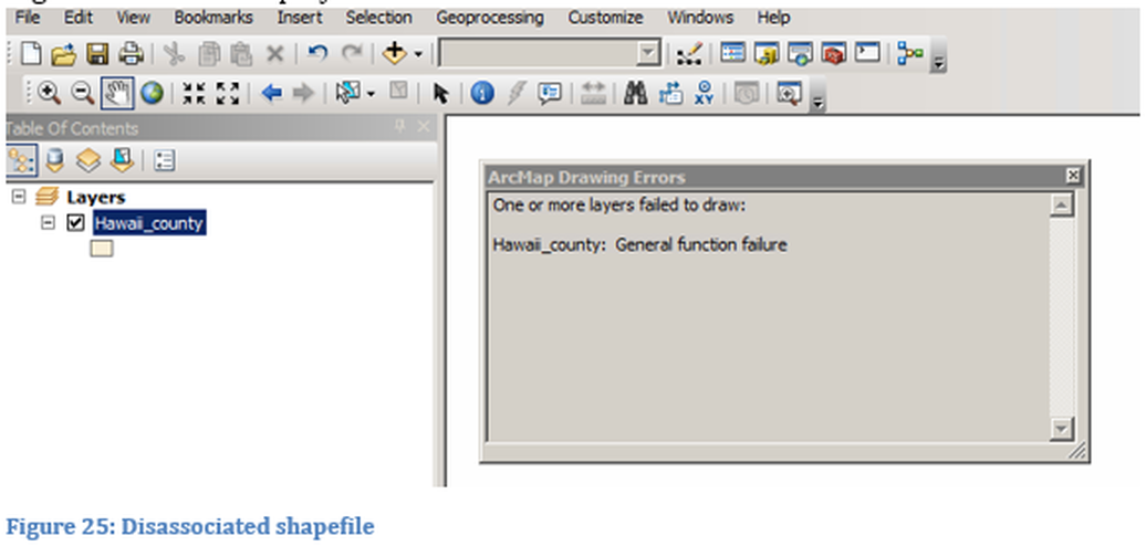
When you create a map in Esri ArcMap and save the work a project file with an mxd extension is generated. This is so that content can be edited in the future. Details of saving data and file methodology will be discussed in the section entitled Managing Geospatial Data. The project file does not save the shapefile data but only provides a pointer to the location of the content. Any symbology and layout created for the map is saved as part of the project file. Once a project is begun data sets should not be moved. If data sets are moved once the map has been created, the data will need to be reassociated before the map can be produced or edited. The moved data will not be visible on the map when the project is opened, but will be listed in the Table of Contents. If the data is moved while the project file is open, a screen similar to Figure 25 will be displayed.
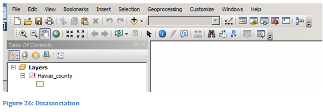
If the file is moved while the project file is closed, the disassociation will be visible in the Table of Contents when the file is opened the next time, as shown in Figure 26. This moving of information might be from one computer to another or one storage location to a different location on the same computer. For example, if data and a project file information are stored on a portable storage device (thumb drive) and the drive is inserted into another computer, the two computers will have different names. Thus when the project file is opened from the thumb drive, even with the same mapped drive letter and same data store, the data will be disassociated as shown in Figure 26. The grayed out check mark and red explanation point represent the disassociation.
If instead the user had used a Network drive or Cloud Storage the data might remain associated and not require rebuilding, especially within an organizational network.
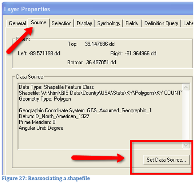
To fix the disassociation problem, the Layer Properties window can be accessed by either double clicking on the shapefile name or right clicking on the shapefile name then selecting property.
To fix the disassociation problem, the Layer Properties window can be accessed by either double clicking on the shapefile name or right clicking on the shapefile name then selecting property.
|
To re-associate the data select the source tab in the Layer Property window. Next select Set Data Source and browse to the new location of the shapefile. Select the shapefile and complete the operation. Depending on how all the shapefiles are stored you may need to repeat the reassociation process for each shapefile.
|
Map Package
Transporting project files from one user to another is not as simple as just providing the project file to the new user due to the issue of disassociation. To transport a map which includes data to another user with complete functionality and not requiring reassociation, the creation of a map package (mpk) in ArcMap is required. The map package will contain all the properties for each layer such as colors, width of lines, queries, labels, etc.; it will also contain the shapefiles data. This tool is located under the file tab, select Share As and then Map Package. A name is provided for the map package and a storage location. Many of the assignments (homework) provided to the instructor should include a map package. If the project (mxd) file is provided instead the assignment will be returned ungraded. By providing the map package the instructor can determine the process and methodology used in the map creation.
Exporting Maps
Maps can be created as static images, such as a paper map or as a dynamic map which can have numerous imbedded properties. A dynamic map is a map similar to a Google Map, while a static image is either an image file, Adobe Acrobat (pdf) or printed map.
To create a static map the process is to export it. The map can be exported as a screen image or a final map with items such as a title, creator information, date of creation, directional arrow, scale and legend. The map can be exported as a graphic image (tiff, jpeg, png, etc.) to be placed into a presentation such as a report or electronic slide show. Another format is the Adobe Acrobat format (pdf), this vector format makes it very accessable for other users since Acrobat viewers are free and the end user can zoom to the maximum scale created by the designer. Other static vector formats such as for Autodesk’s AutoCad and Adobe Illustrator can also be created. All of these vector formats include information so that the map can be placed geographically. The designer will specify the resolution of the output file, the higher the resolution the larger the file size created, but the greater depth of zooming. There are free apps for smart devices to view the GeoPDF file format and use the locator service on the map.
To create a static map the process is to export it. The map can be exported as a screen image or a final map with items such as a title, creator information, date of creation, directional arrow, scale and legend. The map can be exported as a graphic image (tiff, jpeg, png, etc.) to be placed into a presentation such as a report or electronic slide show. Another format is the Adobe Acrobat format (pdf), this vector format makes it very accessable for other users since Acrobat viewers are free and the end user can zoom to the maximum scale created by the designer. Other static vector formats such as for Autodesk’s AutoCad and Adobe Illustrator can also be created. All of these vector formats include information so that the map can be placed geographically. The designer will specify the resolution of the output file, the higher the resolution the larger the file size created, but the greater depth of zooming. There are free apps for smart devices to view the GeoPDF file format and use the locator service on the map.
Data Storage
Storing of data is one of the critical processes in creation of a GIS system. The use of proper data storeage and naming convention makes for effective data management. If proper data management is created from the establishment of the GIS system it will eliminate the needs of reassociation. The development of a data storage methodology is critical before the first data source is created or downloaded. Data should be stored in a manner so that it is easily accessible.
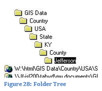
Jefferson Community and Technical College (JCTC) Geospatial Data Library contains extensive amounts of data. The method is based on geopolitical boundaries. The world is the first folder level which contains information about the Earth as a whole, next is individual countries, followed by states (provinces), counties and finally cities. Under each of these geopolitical divisions spatial data is placed in different folders such as shapefiles, data files and compressed files locations. At times a regional geography might need to be added that does not fit these divisions. For example, if working with the service area of a college it will extend beyond a single county but not be across the entire state. Another example would be, while creating a map about earthquakes it was discovered that another regional geography had to be developed, therefore the library needs to be flexible.
The JCTC Data Library is in the process of being migrated from a series of file folders to a group of geodatabases which is a more efficient method of data storage. This transformation requires the use of good naming conventions. For example, a census tract file of Clark County Indiana might be saved with a name such as: IN_Clark_Tract_2000. The file contains information that a user can easily sort, state name, county name, type of information and when it was created.
The data stored will generally be one of two types in this course, shapefiles in file folders or shapefiles in a personal geodatabase. If the data is being stored on a local computer drive it will only be accessible to the user of that computer. If the data is stored on a networked drive, the drive needs to be mapped to a specific drive letter and connected to ArcMap. If the data is stored on a network drive and a universal pathway can be established then the data will not require reassociation from one computer to another. This pathway could be a URL or server path. If the server has a public IP address then the data is accessible within and outside of the network, which assumes that appropriate permissions have been established.
The data could be stored on a geospatial server, either locally, in the Cloud or in ArcGIS Online. The user would be accessing the data as a service which may or may not be editable. The data could also be placed in a relational database such as a Microsoft SQL Server database. Non-editable ArcGIS Server services will be utilized within this course, other methods will not be directly explored.

