County Road Map Case Study
Click here to start watching the County Road Case Study video.
|
Role
The role that you are to play in this case study is that of a geospatial technician, the position could be either a permanent or contractual position. The products to be produced are for both internal use by county employees including the county roads department and external use by the citizens of the county and beyond.
Problem
You have been charged with creating a new county map, containing road with an appropriate classification as well as the classification of streams, lakes and ponds, named places and urban areas. These data sets must be placed in a geodatabase. Furthermore you are to research and place schools onto the map; the schools may be added either manually or by locating a file that shows there location. The resulting school file should be included in the same geodatabase. The datasets will be downloaded from the U.S. Census Bureau and have a classification based on TIGER dataset.
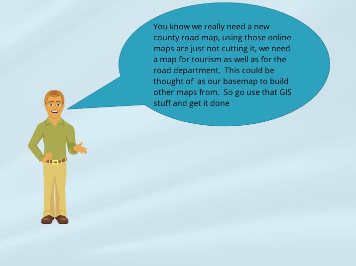
Video File
The video file will provide a verbal charge to what should be created to meet the requirements of this case study. Access the video by going to http://216.69.2.36/software/Storyline%20Videos/Storyline%20Media%20Files/CS%20County%20Road%20-%20Storyline%20output/story_html5.html .
Case Study's Requirement
Create a map that is at a publishable quality for the entire county. In addition more detailed maps must be created naming the roads, when zoomed into an area no greater than 25% of the entire county, these zoomed maps may have slight overlaps (all at the same scale) and make sure that no feature is located on edge of the map. The maps can be either of urban areas or areas of interest, there should be at least four detailed maps created. The maps should also include all features listed above within the county with appropriate colors. It would be helpful to include other geographic information on the zoomed map such as colleges, cemeteries, public buildings, etc. Each map must contain all the appropriate layout information such as legends and scale. A brief report of methodology should accompany the maps.
Technical Skills
The following techniques should be demonstrated as part of this case study. Other technical skills may also be used.
Labeling of map features, without clutter.
Labeling of map features, without clutter.
- Symbology & Classification, to use the appropriate colors and line weights for the items being displayed.
- Publishing the creation of maps that are self-contained documents.
- Editing used to manually add features to maps.
- Report Creation
- Clipping data
- Dynamic Zoom of data
Resources
A single geodatabase (Click Here) for the county is provided to be used in this Case Study. Suggested resources are listed, the learner may use these or other resources.
Optional resources
Optional resources
- ArcGIS server – http://kygisserver.ky.gov/arcgis/services
- County boundary entire state (Kentucky)
- City boundaries entire state (Kentucky)
- Named points (small population locations) entire state (Kentucky)
- Road (local, state, etc.) entire state (Kentucky)
- Rivers entire state (Kentucky)
- Lakes entire state (Kentucky)
- TIGER data which includes rivers, railroads and roads. Boundaries are located here. US Census Bureau http://www.census.gov/geo/maps-data/data/tiger-line.html
- CFCC, MTFCC and TIGER definitions - https://sites.google.com/site/geospatialmaps/resources/mtfcc-code/cfcc-codes
Rubric for County Map Case Study
Required to be turned in:
- Adobe Acrobat files for each map.
- Map Package
- Brief written report of methods.
Required Elements
40 Points
1. Maps must be displayed of a single county.
2. Map must contain roads, streams and bodies of water, named places, urban areas and schools.
3. Map must have:
2. Map must contain roads, streams and bodies of water, named places, urban areas and schools.
3. Map must have:
- Title
- Legend
- Directional Arrow
- Scale
- Author Block
- Entire County Map
- More detailed areas maps
Placement and Symbolism of the Required Elements
20 Points
The location of the publishing elements
1. Appropriate ramp colors utilized
2. Labels turned on at appropriate scale range
3. Appropriate classification of all roads
1. Appropriate ramp colors utilized
2. Labels turned on at appropriate scale range
3. Appropriate classification of all roads
Required Technical Skills Demonstrated
20 Points
1. Labels
2. Classification
3. Publishing
4. Editing
5. Brief Report of methodology
6. Creation of Map Package
2. Classification
3. Publishing
4. Editing
5. Brief Report of methodology
6. Creation of Map Package
Creativity
20 Points
The creativity will include what is presented and how appealing it is to the user. Half of these points will be on how well the designer accomplished the completion of the problem. The other half of the points in this section will be to the functionality and appeal of the maps. The instructor can choose to award more than 20 points to maps that far exceed the requirements.

