Metadata
Metadata is simply data about data. Most of the time when a shapefile is created, there is a specific reason for it. Information about the file includes: the region it covers, the projection of the information, type of shapefile (point, line, polygon), the author, the appropriate use of the information, etc. While this information could be found throughout the file by doing a search of it’s properties, it would require opening the shapefile and manually exploring it. This can be a time consuming process and not efficient. By creating the metadata a user can observe the parameters in ArcCatalog without opening it. Metadata is not just for other users to understand the purpose of a file but actually more for the author. For example, a designer creates a file and does not use it for six months, much of the fine details about the file might be lost, and therefore the author needs to know the purpose and the content of the file to see if it is appropriate for a different project. Tags are an essential part of the creation of the metadata, which also gives the ability to search for information if they are created appropriately.
Data Frames
A data frame contains information about the map that is being created. A single project can have multiple data frames. The initial data frame in Esri ArcMap is called a layer. Numerous parameters can be set in the data frame, one of the most important is the projection. The properties of the data frame can be accessed by right clicking on the data frame. The projection of the data frame can be set directly or when the first shapefile/layer file is loaded, the data frame uses the projection this initial layer. When the designer is in data view only one data frame is visible at a time, within layout view multiple data frames can be placed on a single document. For example if a final map is to have the detail of a single county, but also include an overview map, this would be accomplished by loading two different data frames into the project. For this example the data frames would have the same projection.
Geodatabase
A geodatabase is a specialized database designed for geospatial information. There are different types of geodatabases. A personal geodatabase is used to store only data, similar to a file folder, but the information in the geodatabase can only be accessed from within the software application. Windows Explorer will denote a personal geodatabase as a file folder, when you open the folder it will contain lots of different files but these cannot be directly accessed. When the geodatabase is viewed in ArcMap you can see the individual shapefiles. Only one connection can be made to a personal geodatabase at a time. A relational database allows for multiple users to connect and edit simultaneously. There are numerous free and commercial relational databases that can be connected from within ArcMap. In this course only personal geodatabases will be utilized.
Geospatial Server
A geospatial server, must be a server class machine in which internet protocols have been established, such as IIS or Apache. The geospatial server can provide data in numerous ways, but for this course a map service (Esri format) is the only one that will be utilized. A map service cannot be edited, which includes not being able to modify the symbology. The service can be used as a basemap. Another popular service format is for Google(kml,kmz). The creation of map servers is beyond the scope of this course.
Compressed Data
Most of the information that is downloaded from websites will be in a compressed format (zipped). This is particularly true with shapefiles when multiple files must be moved together from one user to another. It is important to decompress or extract a compressed file before attempting to use the shapefile. If a shapefile is to be shared with others then the file should be compressed. Shapefiles cannot be simoltaniously connected by multiple users and thus must be transported between users as either compressed folders or a geodatabase. Some applications require a geodatabase to be compressed also.
Information must be decompressed (extracted) prior to adding it to a map. Microsoft Windows includes decompression/extraction software in Windows Explorer. There is also free software downloadable from the web that does this operation very effectively. ArcCatalog and the Add Data Button will only show files that can be added to a map, thus a compressed file will not be visible in either of these methods of adding data.
Information must be decompressed (extracted) prior to adding it to a map. Microsoft Windows includes decompression/extraction software in Windows Explorer. There is also free software downloadable from the web that does this operation very effectively. ArcCatalog and the Add Data Button will only show files that can be added to a map, thus a compressed file will not be visible in either of these methods of adding data.
Layer Properties
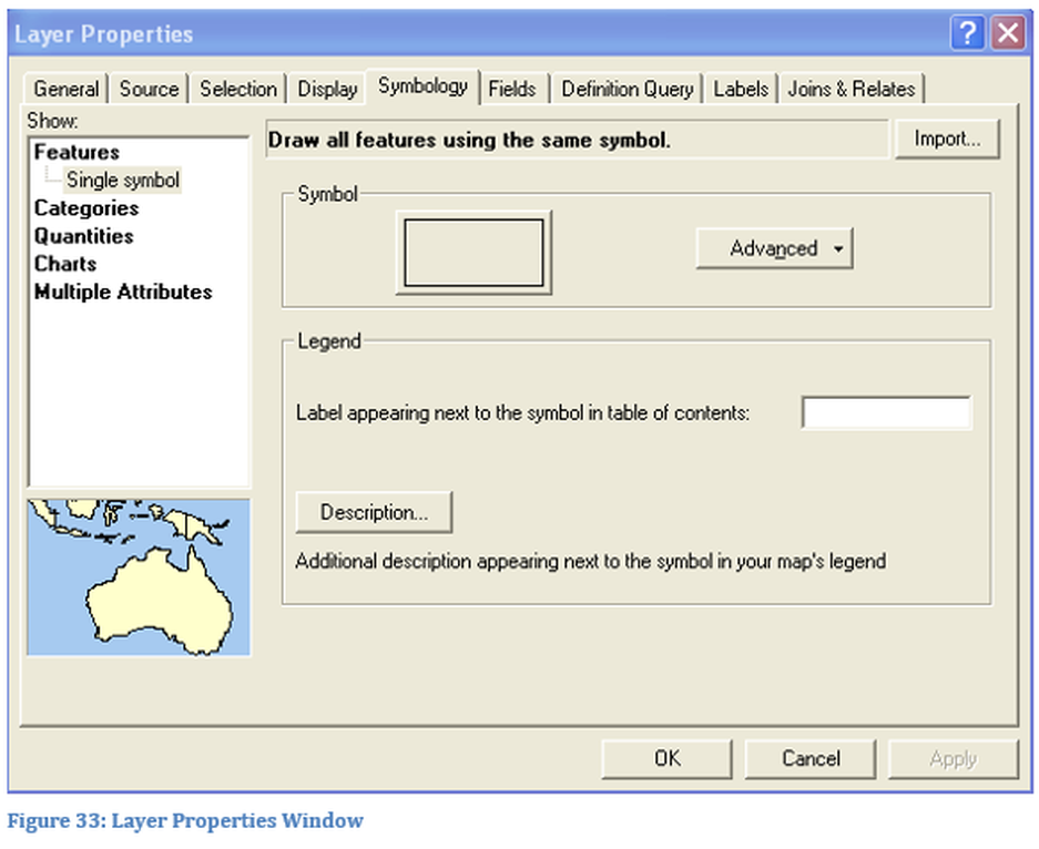
The Layer Properties window gives the designer the ability to access multiple parameters about each layer on the map. As discussed previously, the layer properties window can be accessed by double clicking on the layer or right clicking on the layer name and selecting properties. In Figure 33 the layer property window is shown, there may be some variation in the appearance.

