Managing Geospatial Data - Working with Shapefiles, Geodatabases and Project Files
|
Click here to download the data that the author used for the course lesson. By downloading the data you will be able to follow the steps completely.

|
Introduction to Adding Shapefiles
Only specific types of files can be added into Esri ArcMap, the most common are shapefiles, raster images and tables. There are three basic ways in which shapefiles can be added to ArcMap, other file types cannot be added in the same way due to limitations in the software. Shapefiles can be added using the add data button in ArcMap, using ArcCatalog to put information onto the map or through Microsoft Explorer (File Explorer) by dragging and dropping the shapefile onto the map. It is not recommended that the Microsoft Explorer method be used, but will be included for completeness. Each of these methods will be discussed and demonstrated in this technical skills lesson.
Once the data has been located it needs to be downloaded to a local computer, decompressed, and placed into the appropriate data storage location. In general, the data will be downloaded in a compressed format, because each shapefile contains additional files to function properly and they must all remain stored in the same file folder. The folder must be decompressed so that the files can be used by ArcMap. Remember to name and save the shapefile in an appropriate location, because if the shapefile is moved or the name is changed it will cause a disassociation within a project file. Data for this module can be found at https://drive.google.com/open?id=1jGQdFgNit4cjRA5BYB0WgA42MxUlb0ya or a site that the learner selects.
Data may also be saved in a personal geodatabase, which can be compressed. Geodatabases can only be loaded using the first two methods discussed above.
Using Add Data Button within ArcMap
|
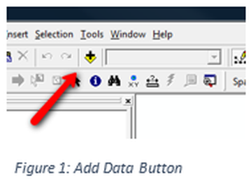
The yellow diamond with the plus sign is the add data button, see Figure 1. It opens a window that looks like Figure 2. There are three primary buttons on the window. The left most button pointed to by the arrow on the left, in Figure 2, is the up one level button, it will navigate to the level above the current folder, but will only go to the highest leveled mapped folder. The middle arrow in Figure 2 points to the Connect a Folder Button. This button operates similarly to mapping performed in Microsoft Windows. It allows the user to determine the lowest folder level of information.
|
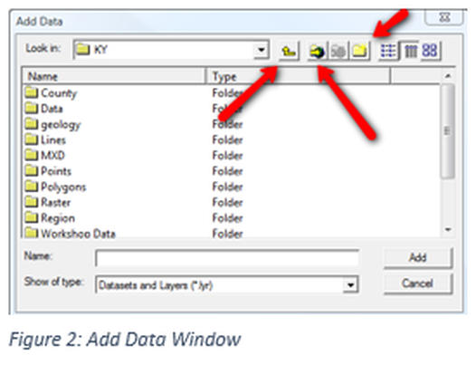
For example, if the data needed is in a Kentucky County folder, mapping to this level would be appropriate. Connecting at a lower level would require mapping of individual counties to be made and mapping at a higher level would require addition clicks to reach the information. The right most arrow in Figure 2 is pointing to the Create a New Folder Button, while it might not be important when you are adding data it can be useful in other applications. By using the add data button only shapefiles are visible and all other file types have been eliminated. This allows the user to visualize a less crowed view of what can be added to ArcMap.
Using ArcCatalog
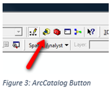
The ArcCatalog button will open the ArcCatalog program see Figure 3. It can also be opened like any other Windows program from the Start Menu. This program looks very much like Microsoft Explorer but is specific for geospatial technology. ArcCatalog only shows files that can be loaded into ArcMap and does not show all the associated files for each shapefile.
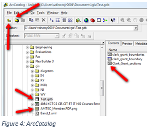
Once ArcCatalog opens it will look like Figure 4. To load a shapefile on to the map click and drag the file to the map. The top two arrows in Figure 4 point to navigation buttons, like discussed in the Add Data Button section. The other three arrows are showing the different icons used, such as geodatabase, a spreadsheet and image files within a geodatabase. These symbols are not visible in Microsoft Explorer.
Using Microsoft Explorer
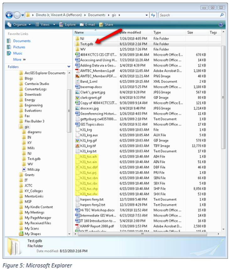
Open Microsoft Explorer then navigate to a folder where shapefiles are located. Select the file with the shp extension and drag and drop it on a map. Note: multiple files of the same name are listed with different extensions, see highlighted text in Figure 5. In addition file types that cannot be loaded into ArcMap are also visible, since this is a general file program and not specifically designed for ArcMap. A geodatabase cannot be loaded in ArcMap using Microsoft Explorer. While this method may initially seem to be the simplest way to load a shapefile it has major limitations over the first two methods discussed. Figure 5 shows the Microsoft Explorer window, this is the file location which was displayed in Figure 4 using ArcCatalog. The arrow in Figure 5 points to the geodatabase, notice it appears to be a file folder, which is the way it will be displayed in the Windows operating environment.
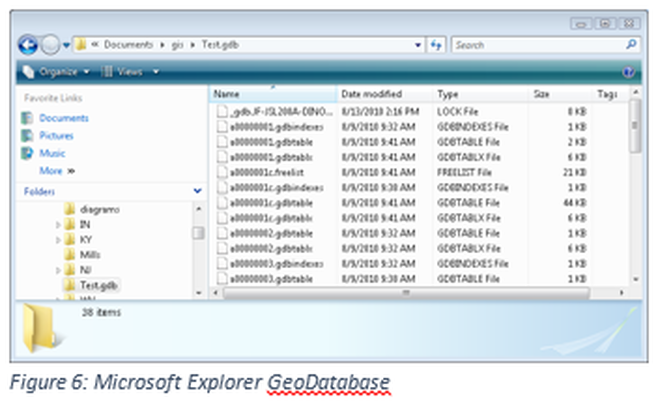
Figure 6 shows the content of the geodatabase, compare this to how the content appeared in ArcCatalog, Figure 4. While shapefiles can be added to maps, geodatabases cannot.
Naming Convention for Storage
1) Files should be placed in an appropriate folder. All files, no matter if they are final files or project files should be stored in a common location, this includes non-editable files, layers should be located in a common folder.
- Data
- Including shapefiles
- Geodatabases
- Spreadsheets (Excel, csv)
- Maps
- Images
- Pdf
- Images
- World – maps of the world or multiple countries
- Country – national or country wide files
- State – individual states within the USA
- Regions – areas within the USA that is composed of multiple states but not on a national scale (a few states).
- World data
- Region_desciption_other needed information_year of data
- MiddleEast_population_2012 (note no spaces)
- Country level data
- Country abbreviation_desiption_other needed information_year of data
- CAN_proviences_population_2012
- For state level data
- Two letter state abbreviation_county name_description_other needed information_year of data
- IN_Clark_Census_Income_ACS2013
- KY_LOU_Sanborn_buildings_1886
- Regional data
- Regional abbreviation_desciption_additional information_year
- LOURegion_Census_Education_2013
- JCTC_Students_Major_F2014

