Introduction to Remote Sensing Understanding the Concepts
|
Click here to download the data that the author used for the course lesson. By downloading the data you will be able to follow the steps completely.

|
Introduction
Remote sensing is the part of geospatial technologies that deals with the detection of electromagnetic radiation to determine characteristics without direct contact. Ultrasonics can also be used which are sound waves and not part of the electromagnetic spectrum. Remote sensing can be passive detection of electromagnetic radiation such as visible light (the colors which the human eye can detect) and the active detection which involves sending electromagnetic energy from a transmitter and detecting the returned signal. For example, every time a smart phone is used to take a picture this is a form of remote sensing, since the detector within the camera is recording the electromagnetic visible light in three different color bins, this is a passive process if the flash is not used. When the flash is used on the smart phone it becomes an active process, since a signal, the flash, is sent out of the device and the device receives the reflected information. Another example of active remote sensing is weather radar, a pulse of energy is sent from the radar station and the reflected information is recorded by an antenna. X-raying a person, would be another form of active remote sensing, since the X-ray machine sends out a beam of energy and what passes through the individual is recorded. For this lesson remote sensing will be of the surface of the earth using aerial vehicles, a more complete coverage of the subject of remote sensing can be found in the remote sensing course.
Remote sensing is always dealing with the reception of information, which can be classified according to the intensity and frequency of the received signal as well as the time from sending of an energy pulse to receiving the returned information. Today the detection of the signal is done by solid state devices, in the early days of this field of study, it was mostly by direct photography. Remote Sensing is a critical component of GEOINT. Remote Sensing uses the concepts of Physics from the fields of Optics and Electromagnetic Theory. Detectors, many times are limited by current engineering principles and the characteristics of optics.
A simple digital camera, like in your phone, is actually a remote sensing device, it is receiving reflected light and is usually classified into one of three bands, red, green or blue. The receiving device has cells, that receive photons. The device can be thought of as having blue cells, red cells and green cells. Together these three cells make up a single picture element (pixel). The more photons in each cell the more dominated that color of light. For example, if only red photons are received then the pixel will be red. If there is a mixing of different colored photons, different colors of light will be created. Depending on the intensity of each of the three colors of light received will determine the color of the object displayed on the screen. There are a few cameras that uses four or five bands instead of the standard three in visible light. A digital camera in an aircraft or satellite works in the same fashion. One big difference in the detector is that it might be receiving light in multiple bands and it may receive information outside of the visible spectrum such as the near infrared.
Software can be used to determine a optical characteristics of a feature, such as grass, which is made up of a little red, lots of green and some blue. Once the ratios of representative colors is known, a spectral signature can be created. From this information it can be determined how much grass is in the image. By using multiple bands (more than three) the ability to accurately determine features is enhanced. Change detection can be done by imaging the same area periodically.
Not all research is done in the visible or near visible wavelength. Thermal imagery is used to determine heat loses, radio/microwaves are used in the detection of elevation, some electromagnetic wavelengths actually penetrate the surface of the earth.
Electromagnetic Spectrum
The electromagnetic spectrum is a family of energy that have both wave and particle properties, which are directly associated with electric and magnetic fields. Visible light is a member of the electromagnetic spectrum as is radio waves, TV signals, and microwaves. Members of this family have similar properties like light, but there are numerous differences. For example visible light will not pass through the wall of a building, but TV signals will. In physics at times the electromagnetic spectrum properties are viewed as a set of transverse waves and at other times as a particle to explain the physical observations. A combinational particle/wave model is not used; but instead for certain contexts only particle models can be used to explain the observations and for others it must be understood as a wave. One model or the other is used and not combined.
When light is considered as a wave it is a three dimensional transverse wave, but in general is represented in only two dimension, for simplicity of understanding. A transverse wave has an amplitude and a frequency, They also have electrical fields that are perpendicular to the magnetic fields and moves perpendicular to the directions of vibration. The electric fields may be in the X, Z plane and magnetic fields in the Y, Z plane and the wave moving in the Z direction. The amplitude of the wave is the height above or below the central axis, in this discussion the Z direction. The frequency is the number of vibrations of the wave in a given unit of time and is usually measured in the Hertz, cycles per second. Since the frequency of waves is a very large number you see Megahertz and Kilohertz when discussing the frequency of radio waves and usually scientific notation for other members of the spectrum. The wavelength of the wave is related to the frequency of the wave since these waves travel at the speed of light when in a vacuum (3 x 10⁸ m/s). The higher the frequency the shorter the wavelength and the opposite is also true. The wavelength of waves might be from several meters to tiny fraction of a meter such as nanometers ( ). The frequency, wavelength and speed are interrelated by an equation; frequency times wavelength equals the speed of light. For example, red light and blue have a different wavelength, thus a different frequency, but the same velocity. The shorter the wavelength the more energetic the wave packet.
When light is considered as a wave it is a three dimensional transverse wave, but in general is represented in only two dimension, for simplicity of understanding. A transverse wave has an amplitude and a frequency, They also have electrical fields that are perpendicular to the magnetic fields and moves perpendicular to the directions of vibration. The electric fields may be in the X, Z plane and magnetic fields in the Y, Z plane and the wave moving in the Z direction. The amplitude of the wave is the height above or below the central axis, in this discussion the Z direction. The frequency is the number of vibrations of the wave in a given unit of time and is usually measured in the Hertz, cycles per second. Since the frequency of waves is a very large number you see Megahertz and Kilohertz when discussing the frequency of radio waves and usually scientific notation for other members of the spectrum. The wavelength of the wave is related to the frequency of the wave since these waves travel at the speed of light when in a vacuum (3 x 10⁸ m/s). The higher the frequency the shorter the wavelength and the opposite is also true. The wavelength of waves might be from several meters to tiny fraction of a meter such as nanometers ( ). The frequency, wavelength and speed are interrelated by an equation; frequency times wavelength equals the speed of light. For example, red light and blue have a different wavelength, thus a different frequency, but the same velocity. The shorter the wavelength the more energetic the wave packet.
At other times in physics we need to consider this family as a group of particles, called photons. A photon is a particle of light which is charge less, massless, with no physical dimensions that travels at the velocity of light. These particles behave much like elastic spheres. For example, when pool ball strikes the side of the table it reflects (bounces) off the table at the same angle in which it struck the bumper as measured to a normal (a perpendicular line to the side of the table); a photon does the same thing such as how light reflects off of a mirror. Different photons have different amounts of energy, thus a red photon has less energy than a blue one. But if we have 10 blue photons and 1000 red photons, the red light will be more intense and have more net energy, but each individual photon will have a discrete amount of energy.
For our discussions we will use either photon or wave. In the discussion of how a sensor works physically it is important that the discussion focuses on the photon. The basic principles of the detector will not be explained. The assumption is that the detector receives a photon of a certain color (energy) and counts it appropriately.
For our discussions we will use either photon or wave. In the discussion of how a sensor works physically it is important that the discussion focuses on the photon. The basic principles of the detector will not be explained. The assumption is that the detector receives a photon of a certain color (energy) and counts it appropriately.
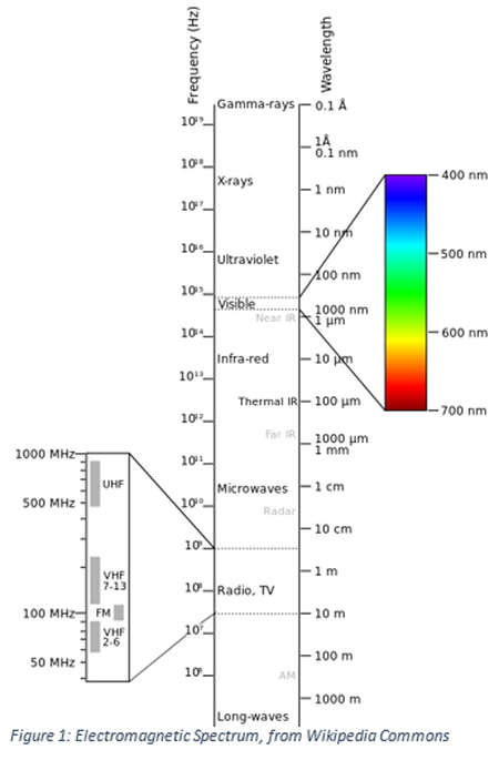
In remote sensing it is very important to understand the nature of the electromagnetic spectrum to understand the type of data that can be received from an aircraft or satellite. Without an understanding of this data type you cannot fully appreciate the nature of the data that you will be using. For example why is one object red and another object green? This has to do with what colors of light are reflected and what colors are absorbed. For something to look red then more red light must be reflected than any other color. Likewise certain wavelength might be absorbed easier by the earth’s atmosphere than other wavelengths and thus the atmosphere is transparent to certain wavelengths and opaque to other wavelengths. It is important to realize that the visible spectrum of light contains all colors, but since the sun is a yellow-orange color more wavelengths are emitted in this part of the spectrum.
Most members of the electromagnetic spectrum are invisible to the human eye. For completeness we will discuss all members of the family initially, but then concentrate on those members of the spectrum that is more commonly used in the study of remote sensing. We will begin with the most energetic members of
Most members of the electromagnetic spectrum are invisible to the human eye. For completeness we will discuss all members of the family initially, but then concentrate on those members of the spectrum that is more commonly used in the study of remote sensing. We will begin with the most energetic members of
the spectrum which will have the highest frequency and shortest wavelengths and finish with those on the lower end of the spectrum with long wavelengths and low frequency.
Gamma Rays – are the most energetic member of the spectrum and are produced in the nuclear decay of atoms and is always associated with other types of nuclear decay (alpha or beta). It is a way in which the nucleus of an atom loses energy. Gamma rays are extremely penetrable and requires a large thickness of lead to protect yourself from these waves.
X-rays – are members of the spectrum which we have some familiarity with, since most people have had an x-ray for a medical purpose. While X-rays can penetrate your body they can be blocked very easily by a thin layer of lead. X-rays are produced when an electrons interact with a metal target in an x-ray machine, they are also produced in stellar processes as well. Few x-rays penetrate the earth’s atmosphere.
Ultraviolet (UV) – waves are very similar to visible light, but are invisible to the human eye. It is used in some settings to sterilize equipment. UV will cause certain inks to glow in the visible wavelengths when exposed. This is the way in which mail is determined to have postage on an envelope, stamps have a layer of ink that is invisible in normal light. UV from the sun can cause skin cancers and the atmosphere blocks much of this radiation from reaching the surface of the earth in a layer known as the Ozone layer. There are concerns environmentally that the Ozone layer is gradually being destroyed. To protect ourselves when outside exposed to the sun, a sun screen with a UV blocker can be used.
Visible Light – Blue light is the most energetic member of this family and red light the least. We are fairly familiar with visible light since that is the way we determine visible factors in our daily lives. It is a set of wavelengths that are used extensively in remote sensing, usually as a passive technology (looking at the reflectance).
Infrared (IR) – radiation is divided into two groups, one known as near infrared and the other thermal infrared or heat.
Microwaves – are a set of wavelength between heat and radio waves, we have a familiarity with this family of waves since they are used for cooking. Since the discussion is from more to less energetic members of the spectrum this raises questions knowing that cooking is quicker with microwaves than most stovetops (thermal IR). Microwaves are less energetic than thermal IR when we look at individual photons, but in a microwave oven we concentrate the number photons used and thus allows most items to cook in a shorter amount of time. Radar is a set of waves that is at the interface between radio and microwaves. Radar is used as an active sensing area in remote sensing also in weather forecasting.
Radio Waves – radio waves are a broad spectrum which includes multiple wavelengths such as TV, traditional radio AM and FM, as well as cell phone communications.
In remote sensing when an airborne detector is used (airplane or satellite) information is sensed in multiple wavelengths, one of the simplest systems is to receive reflectance in red, green and blue. Some sensors will use multiple sensors to expand beyond these three colors and also some sensors will sense in the near infrared and the ultraviolet. By knowing the spectral reflectance of an object in different wavelengths the identification of an object can occur. In addition a diseased plant looks the same in visible wavelengths and very different when observed at other wavelengths such as near IR. For example, a measurement of the amount of salt in coastal area waters can be monitored over time to determine if fresh water is being depleted.
Gamma Rays – are the most energetic member of the spectrum and are produced in the nuclear decay of atoms and is always associated with other types of nuclear decay (alpha or beta). It is a way in which the nucleus of an atom loses energy. Gamma rays are extremely penetrable and requires a large thickness of lead to protect yourself from these waves.
X-rays – are members of the spectrum which we have some familiarity with, since most people have had an x-ray for a medical purpose. While X-rays can penetrate your body they can be blocked very easily by a thin layer of lead. X-rays are produced when an electrons interact with a metal target in an x-ray machine, they are also produced in stellar processes as well. Few x-rays penetrate the earth’s atmosphere.
Ultraviolet (UV) – waves are very similar to visible light, but are invisible to the human eye. It is used in some settings to sterilize equipment. UV will cause certain inks to glow in the visible wavelengths when exposed. This is the way in which mail is determined to have postage on an envelope, stamps have a layer of ink that is invisible in normal light. UV from the sun can cause skin cancers and the atmosphere blocks much of this radiation from reaching the surface of the earth in a layer known as the Ozone layer. There are concerns environmentally that the Ozone layer is gradually being destroyed. To protect ourselves when outside exposed to the sun, a sun screen with a UV blocker can be used.
Visible Light – Blue light is the most energetic member of this family and red light the least. We are fairly familiar with visible light since that is the way we determine visible factors in our daily lives. It is a set of wavelengths that are used extensively in remote sensing, usually as a passive technology (looking at the reflectance).
Infrared (IR) – radiation is divided into two groups, one known as near infrared and the other thermal infrared or heat.
- Near infrared has a longer wavelength than red light and is less energetic, it is used extensively in remote sensing since, green plants emit large amounts of near infrared energy. Thus two objects that visibly appear the same color to our eye, such as a green tree and a green roof will look very different in the near infrared. Near infrared is not the wavelengths used in infrared glasses, these night vision glasses use thermal infrared.
- Thermal infrared is heat, thus different temperatures have different wavelengths. Thermal IR is used to determine the heat lost by objects. Different substances emit heat differently, so how a metal roof of a building emits heat and how the pavement of a road emits heat must be accounted for when determining the temperature of the object. Thus looking at just at the temperature of the object will not directly tell us the heat loss or gain. Temperature and heat from a physics stand point are not the same, temperature is the measurement of how hot or cold something is and heat is the measurement of the amount of energy. On a cloudy night the outside temperature usually stays relatively constant but on a clear night the temperature will drop rapidly, this is due to the amount of water vapor within the atmosphere, water vapor absorbs thermal IR and does not allow it to escape the earth.
Microwaves – are a set of wavelength between heat and radio waves, we have a familiarity with this family of waves since they are used for cooking. Since the discussion is from more to less energetic members of the spectrum this raises questions knowing that cooking is quicker with microwaves than most stovetops (thermal IR). Microwaves are less energetic than thermal IR when we look at individual photons, but in a microwave oven we concentrate the number photons used and thus allows most items to cook in a shorter amount of time. Radar is a set of waves that is at the interface between radio and microwaves. Radar is used as an active sensing area in remote sensing also in weather forecasting.
Radio Waves – radio waves are a broad spectrum which includes multiple wavelengths such as TV, traditional radio AM and FM, as well as cell phone communications.
In remote sensing when an airborne detector is used (airplane or satellite) information is sensed in multiple wavelengths, one of the simplest systems is to receive reflectance in red, green and blue. Some sensors will use multiple sensors to expand beyond these three colors and also some sensors will sense in the near infrared and the ultraviolet. By knowing the spectral reflectance of an object in different wavelengths the identification of an object can occur. In addition a diseased plant looks the same in visible wavelengths and very different when observed at other wavelengths such as near IR. For example, a measurement of the amount of salt in coastal area waters can be monitored over time to determine if fresh water is being depleted.
Platforms
There are three major types of platforms in which the detectors are used for aerial imagery, Devices can also be terrestrial based. A terrestrial based detector might be a device mounted to a vehicle, such as a van used to measure the height of overpasses on an Interstate highway, using a LiDAR detector. The aerial detectors are used classified in one of three groups, satellites, manned aircraft and unmanned aerial vehicles. Each of these devices have specific areas in which they have the greatest effective usage.
Satellite
A satellite in orbit around the earth, in general, has the lowest resolution, but does provide a wide field of view and is periodic, which is great for the measurement of changes. Some satellites are placed in a geosynchronous orbit, but to achieve this stationary position requires that the satellite be much farther from the surface of the earth. Thus the area viewed while constant is much larger and thus less localized details. A weather satellite is an example of a non-periodic satellite in a geosynchronous orbit. Some of the down sides of a satellite are the facts that these orbiting platforms are outside of the atmosphere of the earth, which limits the effective transmission of certain wavelengths through the atmosphere, lack of data on days in which the cloud cover obscures the surface of the earth (unless the satellite is used for weather). Another issue is the size of each individual pixel which are large and small individual structures cannot be identified. In general satellites are passive detectors.
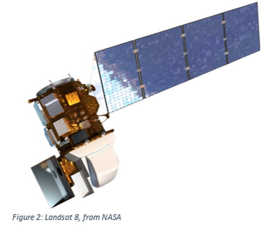
One of the most used periodic satellites used for remote sensing is Landsat. Landsat 8 (launched in 2013) orbits the earth in a polar orbit and images every part of the earth in multiple bands every 16 days. The pixel size varies with different instruments. The satellite has 4 visible bands with a resolution of 30 meters, four near IR bands at 30 meters, panchromatic band with a resolution of 15 meters and two thermal IR bands with a 100 meter resolution. Also available is data from previous Landsat satellites. Note Landsat 7 is still active.
One of the most used periodic satellites used for remote sensing is Landsat. Landsat 8 (launched in 2013) orbits the earth in a polar orbit and images every part of the earth in multiple bands every 16 days. The pixel size varies with different instruments. The satellite has 4 visible bands with a resolution of 30 meters, four near IR bands at 30 meters, panchromatic band with a resolution of 15 meters and two thermal IR bands with a 100 meter resolution. Also available is data from previous Landsat satellites. Note Landsat 7 is still active.
Manned Aircraft
In general a manned aircraft flies at a few thousand feet above the ground to photograph a much smaller area than would be accomplished with a satellite, the detectors also have considerable less atmosphere for the signals to pass through. In addition an aircraft can be scheduled at the specific time needed instead of when the path of the satellite brings the instruments over the target. The resolution of the detected information is a much smaller area down to resolutions of less than 2 inches per pixel. This finer resolution dramatically increases the amount of data received, which can create storage issues. Oblique imagery can also be taken with aircraft through the use of multiple cameras taking multiple simultaneous images and building a three dimensional model.
Unmanned Aerial Vehicles
Unmanned Aerial Vehicle (UAV) or an Unmanned Aerial System (UAS), which are referred to as drones, can take multiple configurations. The UAV is the aircraft, while the UAS is the complete system used. The size of these devices can vary from a few grams to those which are extremely large and used by the military. For this discussion only those used for non-military individualized geospatial purposes will be discussed and many of these weigh less than 55 pounds which mean they are generally referred to as small UAS (sUAS). These vehicles usually fall in to two classifications, those that are fixed wing and those with multiple rotators. The multiple rotator aircraft in general are very good stable platforms, that can hover and can carry high resolution cameras, used for flying relatively small areas. Many of the multiple rotator devices are used as a stationary platform and the camera can be controlled. Some uses include fire and police events, movie making, search operations, and 360 flights around an object. The fixed wing vehicles are meant to fly a pathway and do not hover. The speed of the devices vary with manufacturer but can exceed 50 miles per hour. Since these devices are relatively close to the ground, usually less than 400 feet, the size of an individual pixel can be less than a centimeter on a side. A large amount of data can be collected, each point on the surface of the earth in the study area can be in multiple images. Thus a three dimensional point cloud can be constructed and thus software analysis can be used to do volumetric measurements. Since these objects are in high speed motion care must be taken in determining the shutter speed of the cameras as well as f-stop, focal length of the lens and ASA/ISO.

